

Descripción
Last year, in their Downtown Bicycle and Pedestrian Gap Analysis (http://www.cityofnewhaven.com/TrafficParking/pdfs/GapAnalysis2009.pdf), Nelson\Nygaard Consultants recommended a physically separated bike lane—or cycle track—on Elm Street. How would you design such a facility? View a 3D mock-up of two potential designs here and offer your suggestions. Don't like it? Download Google SketchUp to your computer here: http://sketchup.google.com/ and then download my drawings here: http://www.box.net/shared/z8e1db4ssq and give it your best shot.
For cycle track design guidelines and best practices, have a look at this design guide from the National Association of City Transportation Officials: http://nacto.org/cities-for-cycling/design-guide/cycle-tracks/
and this report from bicycle-oriented transportation planning consultants at Alta Planning: http://www.altaplanning.com/cycle+tracks.aspx


93 Comentars
Brian Tang (Usuario registrado)
Brian Tang (Usuario registrado)
http://www.box.net/shared/02qi9in3nm
Reconocido Department of Transportation, Traffic and Parking (Usuario registrado)
Brian Tang (Usuario registrado)
Brian Tang (Usuario registrado)
http://www.box.net/shared/z8e1db4ssq
resident (Invitado)
bikenewhaven (Invitado)
This is tough. I think there's a good argument to be made for both sides of Elm St. needing the track. The simulation, just like in real life, seems smoother on the left side (esp. @ Elm/Temple where the buses get backed up), and obviously it would connect well to East Rock where many riders live. But ideally a track on the right side would connect riders coming from the west to Yale-New Haven/ the Hill/ City Point (via College St.), to Ninth Square (via Orange St.), to Wooster Sq. and Long Wharf (via State St.) and to Fair Haven (via Grand Ave.)
I guess the best solution would be to have one on both sides.
BB (Usuario registrado)
How do people get off the track to get onto temple and college going South?
Brian Tang (Invitado)
CT Livable Streets Campaign (Usuario registrado)
Seems great to me. The lack of a cycle route from the west side of New Haven, into downtown and neighborhoods beyond, has been a serious issue for decades. A cycle track would help solve that.
Ideally, if New Haven wants to become a progressive and economically vibrant city, it should be a two-way cycle track (not only because that is what very progressive cities like Amsterdam, Stockholm and Copenhagen use, but also because that is how people will actually use it and you aren't going to change millions of years of human evolution overnight), but many would be happy with the next best thing.
Brian Tang (Usuario registrado)
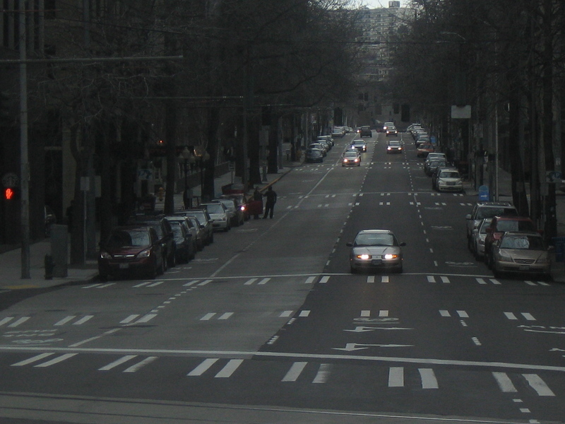
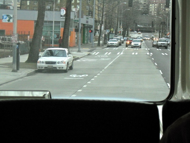
I was riding the bus on Stewart Street in Seattle and I noticed that they had just striped some new sharrows. Stewart Street is about six to eight feet wider than Elm Street, but is otherwise pretty similar. What they did in Seattle was put sharrows on both the right-hand and left-hand lanes. Both of these lanes are used for parking during off-peak hours, with the result being that they function as shared lanes during peak hours and bike lanes during off-peak hours. I'm not sure how much of a dooring risk this creates, but it's and interesting concept. (see photo).
I was going to revise the right-hand configuration diagram to include sharrows in the left-hand lane, but it turns out I forgot to upload the components that I used (bike lane and sharrow symbols). Sorry to all of you who attempted to work on the model but opened it up to find no bike lane symbols. I'll upload those as soon as I get back to campus in a week and a half.
Also, ignore the comment that instructs you to ignore the link in the issue description. I wrote that comment before I realized you could edit issue descriptions.
Brian Tang (Usuario registrado)
Brian Tang (Usuario registrado)
http://www.nacto.org/downloads/cycletrack_lessons_learned.pdf
Let me know if you see any ideas from this document that suggest the need for a change in the Elm Street proposals.
Melissa (Invitado)
Brian Tang (Invitado)
Yes. Sharrows on Grove St and on Chapel St going westbound are supposed to be painted sometime before June 30th.
Sharrows are also supposed to be painted on George St to serve eastbound bike traffic until adquate funding and support can be assembled for Elm St.
Personally, I'm leaning toward the right-hand configuration with supplementary sharrows running down the left-hand side for those who prefer the left. There are two main reasons why I prefer the right-hand configuration: a) it would not require the elimination of on-street parking and b) it would better serve people coming from Howe St, which I anticipate will be the origin of most of the Elm St bike traffic.
When I have the chance, I will revise the diagrams to include bike boxes on College St and Church St in order to assist people who want to go left but find themselves on the right-hand side of the street. I will also add those sharrows and try designing the cycle track to the Alta specifications to see how it looks.
At this point, the City is interested in this project and what is needed mainly is addional community support. Frankly, I'm a little embarrassed that gigabit broadband has more followers than this issue. What's up with that?
Carl (Invitado)
Melissa (Invitado)
alexey (Invitado)
Walt (Invitado)
Hope you get your sharrows, but if you ride as in Tang's 3D, goinjg straight in a " left turn only" lane, stupidly cutting in front of a tractor /trailer, and weaving in and out of traffic, you wont enjoy the new arrangements for long.
Bikists should obey traffic laws as do most drivers. If you drive as Tang's illustration suggests you should be arrested.
Thought you folks supported sensible biking, Apparently was wrong.
juli (Usuario registrado)
walt, i am curious: where in this plan did you read about a cyclist weaving in and out of traffic?
also, could you please retire the word bikist, as it is not actually a word at all.
( http://dictionary.reference.com/browse/bikist )
i think this is a fantastic way to make elm street accessible to riders of all levels, instead of just a speedway to the highway.
Greg (Invitado)
Walt (Invitado)
juli
Watch the video.
Apparently Greg sees the same things in the video as I did, but thinks, and may be correct, that Tang did not mean them, but nevertheless, that is what he pictures.
As to bikists, you are right, it is not yet a recognized word. I invented it to differentiate bike riders from bikers. Prefer it to cyclists.
Hopefully not Tang's intention, but bikists in his video are shown as reckless and a danger to others as well as themselves
Do not plan to drop it now, but probably will before it becomes a new legitimate word, but may not
If you do not like it, do not use it..
Brian Tang (Usuario registrado)
Woww... cool it down people. I take a week off from SeeClickFix to volunteer building houses in New Orleans and this is what happens?
Walt, I included those hairy situations for three reasons, a) because I am not a professional 3D animator and do not have to software necessary to make the cars move, b) because I wanted the animation to illustrate the worst possible scenario, highlighting any possible drawbacks in order to assist in comparison between alternatives, and c) because I think most animated simulations are boring and I wanted to spice things up a little.
In real life, the cars in the combined right-turn/bike lane would be moving with the same speed and direction as bicyclists, resulting in minimal conflicts.
Furthermore, if Walt or anyone else has a problem with how I designed the bike lane in this conceptual simulation, please do not just sit there and complain about it. Instead, if you don't like my proposals, download Google SketchUp to your computer (for free) here: http://sketchup.google.com/ , then download my drawings here: http://www.box.net/shared/z8e1db4ssq , and give it your best shot. I just uploaded all of the components associated with the models in a folder in the box.net folder entitled "components." You will need to download them and add them so that the model can reference them. I look forward to viewing your proposals and design modifications.
— Brian Tang
Walt (Invitado)
Thanks for explanation
Wont compete re 3D. Just an anateur with computers who thought the wild driving by bikists was odd, but your skill was impressive.
Brian Tang (Invitado)
Brian Tang (Usuario registrado)
To address a few other comments, specifically Alexy's and Carl's, the reason you don't see physically separated bike lanes all over New Haven (or just about any American city, for that matter) has a lot to do with the concerns you have raised, namely that cycle tracks make it more difficult for cyclists to merge out into traffic, more difficult for street sweepers, and more difficult for snow removal. That said, I do not find any of these challenges to be insurmountable, nor do I find them to be reason to abandon the idea of physically separated bike lanes.
Sidewalk-sized street sweepers and sidewalk-sized snow plows (a.k.a. Bobcats) both exist and would be ideal for cycle tracks. As for the merging issue, I have tried to address this by leaving about 30' of space at the beginning of each block where there is no physical separation and bike riders will be free to merge. In future revisions to the right-hand configuration, I will also add sharrows down the left side of the street to make it clear that you are still at liberty to use the auto lanes if you so desire.
If you are wondering why cycle tracks are favored over sharrows or bike lanes on busy streets, I wrote down my thoughts on the matter in a document called "Why Cycle Tracks," which I have uploaded to the box.net folder: http://www.box.net/shared/z8e1db4ssq
If you are wondering where you can find the Nelson\Nygaard report that recommended a cycle track on Elm Street, it is located here: http://www.cityofnewhaven.com/TrafficParking/BikePlanning.asp
Hopefully that addresses all of the concerns that have been raised so far.
Walt (Invitado)
Brian Tang
Hostility may be close,, but concern about the bikists is part of it, and the belief that the motorists' side of the story seldom gets told because of the predominance of Elm City Cyclists Board members among posters results in a biased view also leads to my posts.
Some bikist posters are more anti- motorist than pro-bike.
It appears less so with many of your fellow Board members..
Your group preaches safety and I would agree with most of your suggestions other then the take the lane idea.
When you produce a video portraying bikists breaking the law, and acting idiotically, as you did, I will comment even though you later say , correctly I assume, that that was not your intent.
When Streever whom I consider among the more sensible bikists despite his recent problem,, complains that traffic signals in my neighborhood do not automatically change for bikes ,as he did, I will point out that they do not do so for cars either and that his complaint appears without merit.
I will gripe when bike-jerks (Is that better than bikists?) as they did in the dark at about 6: 20 this morning on Ridge Road near Skiff St. travel 2 abreast, dark clothes, nothing reflective on the outside rider and very weak light on the inside rider.
I do not wish to come upon the corpses of these jerks who stupidly put their lives at risk for no reason, or worse, that I be the guy who runs over them.
As said, Streever complained that his bike wouldn't change traffic signals, but most of the bikists I see in the Ridge Road/ Htfd Tpke. neighborhood would not care because they ignore the lights, stop signs and other traffic controls and go right on through.
So if you want to call it "hostility" go ahead. I say "legitimate concern".
Ben (Invitado)
So to get things back on track (pun intended)
What is the timeline for something like this Traffic and Parking?
On my way into work today it was awesome to see cyclists in front and behind me on State Street. Can't wait for this summer's improvements.
Brian Tang (Usuario registrado)
I just ran across this sweet video out of Portland all about cycle tracks:
http://vimeo.com/10559007
Think about it. We could be one of the first cities in the U.S. to test out cycle tracks too!
Walt (Invitado)
Item killed re bike topic where someone faked Streever's having criticized bikists and topic was justly removed.
Suggest the pro-bike person who claimed on that issue that bikist parades as mentioned in that article legally crowd out other traffic, blocking other traffic, read Section 14- 285(b) of the CT General Statutes which pretty well covers the topic, prohibiting more than 2 abreast and intentional interruption of traffic as is done when the bikists move illegally en masse.
Whether it is OK when accompanied by cops as is done in New Haven, is questionable Saw another bikist mob head down Skiff to State with no cops, I believe , hustling through the red traffic light (North Haven?) recently
Illegal!!!Time to crack down!
On a related topic, how can someone illegitimately post in Streever"s name when Email address is required with each comment? Just curious!
Maybe the culprit is the same jerk who "supported" this fake effort about 20 times in a row, just above.
Walt (Invitado)
juli (Usuario registrado)
walt, your comments only affirm how much effort our city needs to put into adjusting the infrastructure to protect cyclists from such venomous drivers with anti-cyclist agendas.
KEEP YOUR COMMENTS ON TOPIC. and, as brian so delicately put it above, if you have nothing positive to add to the forum of seeclickfix, then stop wasting everyones' time.
Walt (Invitado)
Walt (Invitado)
Obviously, from the notes sent by Juli now and earlier, only pro-bikist comments are welcome to her Similarly earlier comments by Tang .
If you do not like truth, tough.
Obey the laws, and if the rest of the bikists did the same, and stopped misquoting the law, I would have nothing to gripe about re their claims.
If See Click Fix folks officially object to my beliefs when I am just trying to present a bit of the other side of the story, and to point out when laws are misstated or broken or topics are misleadingly pictured , as Tang's were, (not intentionally, I would probably agree), that is their privilege.
Unless I am censored and they do not wish the truth, I'll comment when I believe facts are distorted or misstated.
Walt (Invitado)
Question for Tang
If there is a place for your bike track idea to be tried, Whalley Ave,, seems to be a good choice,
Unless I misunderstand, a new curb would separate it from auto traffic.
In your plan how are such things as sweeping and plowing handled as current equipment would not fit bike tracks (I think)?
Thanks
Ben (Invitado)
we most definitely welcome desenting opinions. Also, feel free to start a no cycle track needed issue.
Walt (Invitado)
Thank you Ben
I am really neither for or against the cycle track plan plan being proposed for trial on Whalley Ave.
Just against false or misleading statements,
I am for better enforcement of laws re bikists (as well as car folk) but that, as I see it.does not make my position "venomous" or "hostile" as it has been described, .
My question re sweeping or plowing was already answered by Brian Tang, I now see.
I might very well object to the added capital and operating expense required and propose that the bikists toss in a few bucks themselves ( maybe via bike registration or a toll path), although in the current situation, the feds may favor it as a true job producing deal and happily throw money at it.
Glad to see someone on the bikists' side who has no fear of dissent .
Walt (Invitado)
Sorry Ben
You are really the big honcho of See/Click/Fix , backing up my free speech, aren't you ?
I plead senior slowness.
Thanks again
Brian Tang (Usuario registrado)
Hey everyone,
I've done nothing but work on a research paper about the lack of federal oversight of coal ash disposal for the past four days and I'm a little out of the loop on what all the comments are about.
Walt, plowing and sweeping is certainly a concern. My intention with the original design was that maybe we could work out a deal with Yale where they would sweep/plow it (they have sidewalk-sized snow removers and sweepers). Lately, I've been looking into the idea of putting the cycle track closer to the sidewalk level, which might reduce the need for sweeping. I'm not entirely sure how drainage is supposed to work with the raised tracks, but that is how they are done all across Europe, so it must work somehow. I haven't had much time to look into the issue lately.
Lastly, to the recent commenters, try to bear in mind that every post to this issue is emailed out to 70 other people. If any of them are like me and underwater in either schoolwork, professional work, or just life in general, I think a lot of people would appreciate it if you only comment if it is truly something helpful and relevant to the issue. You certainly have the right to say anything you like. It’s just a matter of courtesy, really.
Thanks!
Brian
(no need to reply. I could use some silence in my inbox right now.)
Citizen (Usuario registrado)
...whalley avenue? Are you kidding? Theres a reason that bikers try to avoid the street (I for one NEVER ride my bike on there) and that's because it's not meant for bikes!! It's meant for heavy auto traffic. Putting a "cycle track" or even a bike lane at all would:
a. Increase the amount of deaths of cyclists
b. Jam up traffic even more on Whalley
c. Have no effect, as people driving on Whalley Avenue usually do not follow the laws of the road anyways.
The whole uptown to downtown bike route should not take place on Whalley at all. A good alternate road is Edgewood Avenue, which for sure (a) has the space for a "cycle track", and (b) does not have as much heavy traffic as Whalley does.
And as for Elm Street, you're talking about downtown, by Yale, right? It, too, has very heavy traffic (as it is Whalley Avenue, merged into Elm). I just don't know about putting a track there. It seems like a good idea, but I just don't know - I'm worried about the safety of both the cyclists and the drivers, here.
To generate the entire city bike route, we can't just pick out different roads which we think might look pretty, especially to Yale tourists. We need to seriously think about the route, the safety of both sides of the road, and what would work best. I've got to say Brian - you've got the right idea - but not on Elm/Whalley.
Bill (Invitado)
Yes, women and children don't flock to Whalley Ave. for an afternoon bike ride, but there are still plenty of us who do use it daily for transportation (i.e. commuting to work, school, meetings/gatherings). We are not intimidated here, otherwise why would so many of us use it. Although the traffic does flow a little faster on Whalley than on, say Edgewood Ave., it's much too practical and convenient to give up. If anything, the functional role of Whalley Ave. proves that it needs better bike infrastructure.
A cycle track or bike lane would not slow down traffic. On the contrary, it would eliminate a huge amount of short-trip drivers (0-5 miles) by making it safer and more attractive for them to use a bike on Whalley Ave. Simultaneously it would make them healthier and happier. Not such a bad thing.
Carl (Invitado)
Brian Tang (Usuario registrado)
Please note that the proposed Whalley Ave cycle track can also be discussed on the issue entitled “Ideal location for a cycle track” located here:
http://seeclickfix.com/issues/9507
As for directing bicycle traffic onto lower traffic streets, I generally agree with that philosophy, as it can give you a much greater bang for your buck and can allow for the development of some really first-rate cycling facilities (e.g. “bike boulevards” in Portland and San Francisco). Specifically, I have in the past recommended Wall Street as an alternate route for Elm Street bike traffic in Downtown.
While Wall street is generally superior for bicycle travel within downtown, it is inferior to Elm Street in its connection to Grand Ave and it lacks any connection at all to bike routes west of downtown (Howe Street and Goffe Street). While Wall Street could affordably be made into an excellent bicycle facility serving traffic within downtown and connecting to bike routes to the northeast of downtown, Wall Street cannot adequately serve through bicycle traffic.
For this reason I have concluded that a cycle track is needed on Elm Street.
Brian Tang (Usuario registrado)
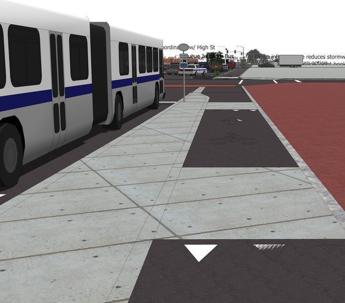
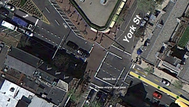
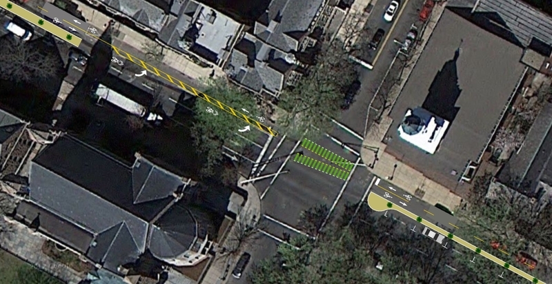
I’ve been working furiously on a revised conceptual plan. It would be significantly more expensive than my initial proposal and would probably take something on the order of 3–5 years to implement. Here is the first of a series of sneak previews. It’ll probably be another week until I have the drawings completed and can make another animated simulation to upload to YouTube.
This image depicts a sidewalk-level cycle track in between a bus stop and the sidewalk at the corner of Broadway and York Street in front of Tyco.
Brian Tang (Usuario registrado)
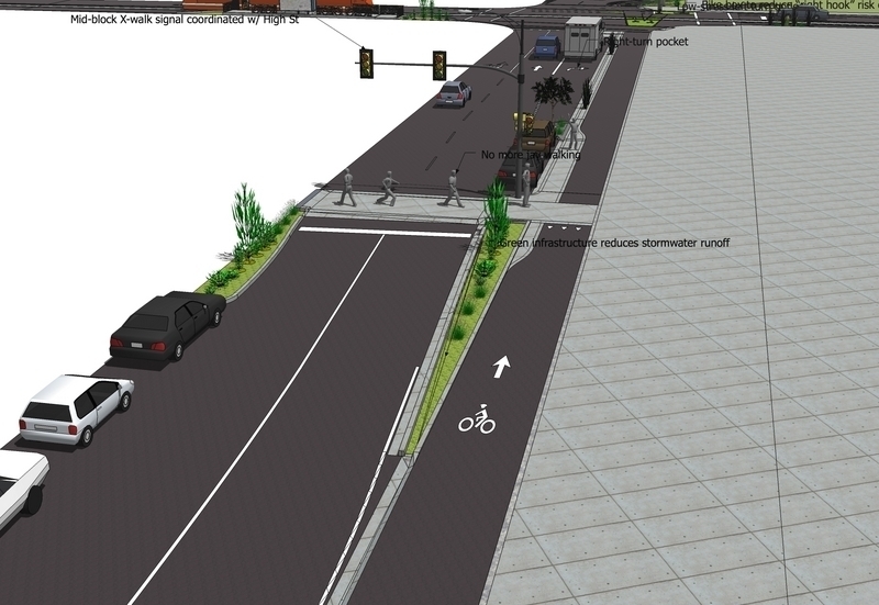
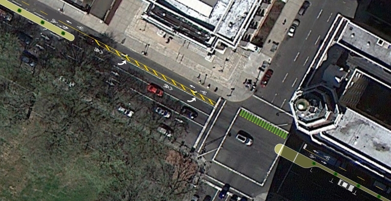
One element of my revised proposal is an emphasis on green infrastructure. Green infrastructure design elements such as biofiltration swales and street trees intercept rainwater, add to the urban tree canopy, and reduce pollutants that enter the West River, Mill River, and Long Island Sound either through combined sewage overflows or through (future) separated stormwater systems that dump untreated road runoff directly into our watersheds. Additionally, I hope that roadside bioswales will provide good habitat for grasses and other vegetation native to Connecticut’s estuaries (salt marshes) and riparian areas.
This image depicts a roadside biofiltration swale on Elm Street east of College Street. In the background, you may notice the proposed streetcar on College Street. The upper Green is to the left. Elm street is depicted as having two travel lanes and parallel parking on both sides of the street at this location. Some elements of my drawing visible within this rendering are not yet completed.
Brian Tang (Usuario registrado)
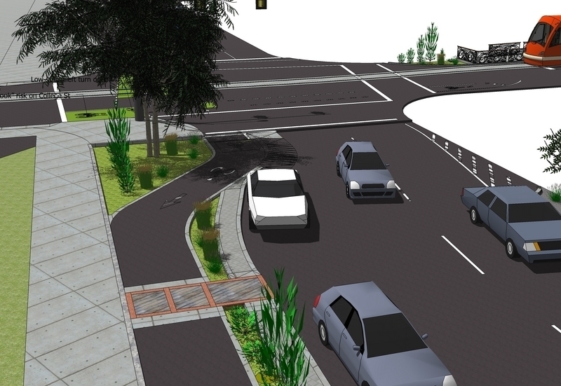
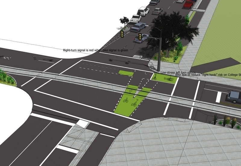
Per Ben’s comment on the initial proposal, I have included a low-stress left turn option for College Street. This is based roughly on the left turn system used on Portland’s Broadway cycle track.
Some elements of my drawing visible within this rendering are not yet completed. Also note: the bicycle symbols within the green carpet paint are supposed to be white, but a glitch within the software prevented them from rendering correctly.
Brian Tang (Usuario registrado)
Brian Tang (Usuario registrado)
Anonymous (Invitado)
Brian Tang (Usuario registrado)
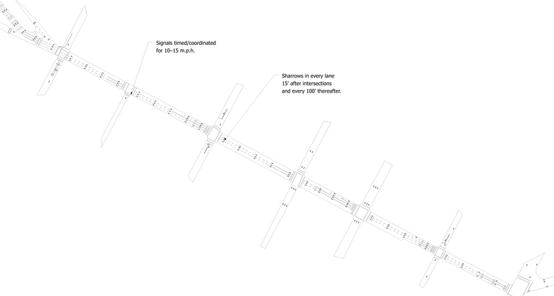
All alternatives are worth considering. Just for you, I have drawn up a “no build” alternative. See attached image, available for download here: http://www.box.net/shared/368344kfkz
The essential components of this alternative are:
— Downtown signals timed for 10–15 m.p.h.
— Sharrows painted in every lane 15' after every intersection and every 100' thereafter.
Citizen (Usuario registrado)
I love your new renderings, Brian. It looks to me like you are proposing that, on Elm St at the bus station, the cycle track would go to the RIGHT of the buses, I think thats a great solution to the problem! I must say, that really seems like a realistic thing that can be done.
Well done. No comment on the streetcar, though :D
Brian Tang (Usuario registrado)
I just finished a webpage on the Elm City Cycling website that synthesizes everything that has come out of this process so far: http://www.elmcitycycling.org/elmstreetdowntownr/
I hope you like it! Let me know what you think.
—Brian
Anonymous (Invitado)
amy (Invitado)
Brian Tang (Usuario registrado)
The ECC webpage on this issue now has a new URL: http://www.elmcitycycling.org/closethegaps/elmstreetdowntownr/
The new URL is because it is now part of a broader project to close gaps in bike routes across the city: http://www.elmcitycycling.org/closethegaps/
Brian Tang (Usuario registrado)
This provides plenty to think about:
http://nacto.org/cities-for-cycling/design-guide/intersection-treatments/cycle-track-intersection-approach/
Looks like I should go back and make a new drawing.
CT Livable Streets Campaign (Usuario registrado)
Thanks Brian. That is a really helpful resource about cycle track design.
The city told a community group recently that they are still interested in the concept of a cycle track on Elm Street (it was promised in the Department's "Annual Report" goals, which go to the Board of Aldermen for last year and I think the year before too) but that they've run out of funding to do any planning work for it this year. It's too bad that the Department's "Annual Report" includes goals that have no reality of happening, but such is the situation with budget cuts.
Elm City Cycling will push for it next year. Please vote here and circulate this issue to help build support and get it to happen.
David Streever (Usuario registrado)
CT Livable Streets Campaign (Usuario registrado)
It would be great if stuff like this went right into a work order.
Yes, making an official complete streets request would be very helpful, since that would get this project on the official record for the Aldermen to review each year. As the number of requests builds, and the number of projects actually completed stagnates, there should be more and more political support to expand the program.
It's important to document and track complete streets requests over time - otherwise it seems that city funding would just get distributed willy-nilly, instead of based on a priority system. Also having them document lets citizens prove that requests have been on the table for a long time.
I wish more folks would fill out the CS requests and document the top concerns in their neighborhood! I think the city may need to do some work to make them more accessible, and also encourage Aldermen to use them.
The city administrative departments seem to use SCF for certain quick-fix concerns, like graffiti, parks, potholes and bike rack requests. The bigger things like this don't ever seem to go into work orders, maybe because there isn't a source of funding available. But I think they still make a difference. One example: restoring library hours, which was one of the most popular issues recently, and which the Aldermen voted to incorporate in the budget last time I checked.
cyclist (Invitado)
I think the problem with this corridor is that too many streets converge onto Elm: Whalley, Dixwell, Goffe and Elm, and most of this traffic is not local traffic, but is bound for the freeways.
The best way to make this corridor both bike and pedestrian friendly is to establish an alternative traffic route to the freeway. People run lights here and have little concern for cyclists or walkers because they are in a rush to get to the 95.
I am all for more bike infrastructure, but what I really wish is that the city would work with Elm Cycling to develop a comprehensive traffic plan, one that makes logical sense and is designed to keep traffic moving instead of stopped. The most dangerous part about riding your bike in New Haven is driver road rage, which can only be abated through comprehensive planning.
zbeat (Usuario registrado)
Dear City of New Haven Department of Transportation, Traffic and Parking:
Thanks for acknowledging this issue, nearly 2 1/2 years ago. If it's not too much trouble, would you elaborate on that acknowledgment? Specifically, I'd like to know:
1) AT THE TIME, was this slated for further research? Or was it desired but unfunded? Or not desired (which would have warranted closing this issue)?
2) CURRENTLY, what is the status of this request?
Any further details would be appreciated. Thanks!
-Zack
CT Livable Streets Campaign (Usuario registrado)
I agree with Zack. This project was listed as a priority in TTP's 2009 annual report as well.
The renderings by Brian Tang show that something like this could dramatically improve the accessibility of the City for bus riders, walkers and cyclists. Something like this would be great especially as we gear up to celebrate the 375th anniversary of the creation of the New Haven Green.
Brian Tang (Usuario registrado)
The signals on Elm St have finally been synchronized! Unfortunately, they have been set up for *average* travel speeds of 25 mph. This means that if there is any delay at all (which is inevitable at most times of the day), one must accelerate to top speeds of 35 to 40 mph once things open up between College and Church to make up for lost time. Otherwise, either Orange St or Church St will change to red just before you can get through. 35 to 40 mph is much too fast for downtown, yet this is what you must drive for the two blocks from College to Church if you want to get all green lights from York to State.
If we cannot afford to build a separated bike facility for Elm St, then we at least need to synchronize the signals for speeds that bicycles can maintain. This means top speeds of 20 mph (average speed of about 12 to 15 mph), not the current top speeds of 35 to 40 mph (average speed of 25 mph).
Ben (Invitado)
Do you know the cost of such a bike structure?
CT Livable Streets Campaign (Usuario registrado)
I agree with Brian that the synchronization needs to be revisited.
Regarding cost, adding a separated bike facility over the entire length of Elm Street, from Park to State, would not be particularly expensive relative to the number of persons who use this street. The half-mile long "Kinzie" protected bicycle lane in Chicago cost $140,000 to install.
Brian Tang (Usuario registrado)
BB (Usuario registrado)
Brian Tang (Usuario registrado)
I think the most effective way for individuals to support this project would probably be through time and enthusiasm, not money. I don't really see funding as the main obstacle here. While we have completed our most basic conceptual phase (proposing the idea of a cycle track and explaining what that can include), there is still quite a bit that we need to do to truly get the ball rolling. The fact is, this proposal faces some real and significant design constraints that will require trade-offs that have the potential to generate controversy, or perhaps even opposition. For example, there is no obvious answer for how to route a bikeway through Broadway. There is significant bike traffic from Tower Parkway to Broadway—some of which needs to merge right, to go to the Howe St/Lynwood area, to go to Park St, to got to Saybrook/Branford, to go to Old Campus, or to go to College St southbound; and some of which needs to keep left, to go toward Ashley's Ice Cream, the libraries, or College St northbound. I have no obvious prescription for how to approach this design challenge and reaching a consensus will take significantly more discussion.
The question now is whether any of you reading this happen to see an ingenious and elegant solution that I am not seeing. If you do, we need your help. Or perhaps you have creative friends familiar with the area who wouldn't mind tossing in a few thoughts.
Once we have some creative solutions to work with, we will be ready to move onto the next step: expanding our public outreach to try to reach more stakeholders, principally: CT Transit, Yale, people who live along Whalley, Dixwell, and Goffe. That will allow us to begin to try to build a consensus. Once we have a broad community consensus, working out the funding and implementation through Transportation, Traffic and Parking will be a piece of cake. But we are not there yet; we need a broad community consensus for this project to move forward.
JustAnotherCyclist (Invitado)
JustAnotherCyclist (Invitado)
Brian Tang (Usuario registrado)
Brian Tang (Usuario registrado)
Something like this might work well and not cost to much to design and implement:
http://greenlaneproject.org/blog/view
You would want dedicated bike signals at College, Church, Orange, and State. I'm not sure how much that would cost, but it would probably be the most expensive part of the project.
Brian Tang (Usuario registrado)
OK. What do you all think of this idea (attached image)
It's basically a combo of the two-way Chicago bike lane design: http://greenlaneproject.org/blog/view/a-great-day-in-chicago-green-lanes-open-in-the-heart-of-the-loop and what I think is a more attractive painted buffer that just débuted in Portland: http://bikeportland.org/2012/12/11/questions-about-colors-on-ne-multnomah-81100
both of which are shamelessly copying New York City, anyway.
Downsides:
— It would eliminate one travel lane AND all on-street parking for the two-block stretch from York St to College St.
— It would require dedicated bike signals at York St, College St, Church St, Orange St, and State St.
Upsides:
— Could be built on a reasonable budget (would not require tearing up and rebuilding any part of the street). The design work, paint, and planter boxes would probably cost about $50,000. The signal work would probably cost… a lot—I don't even know.
— Two-way bike travel!!
— A million times better than my original proposal (which I am embarrassed is even still posted here).
JustAnotherCyclist (Invitado)
Brian Tang (Usuario registrado)
Brian Tang (Usuario registrado)
Brian Tang (Usuario registrado)
Brian Tang (Usuario registrado)
JustAnotherCyclist (Invitado)
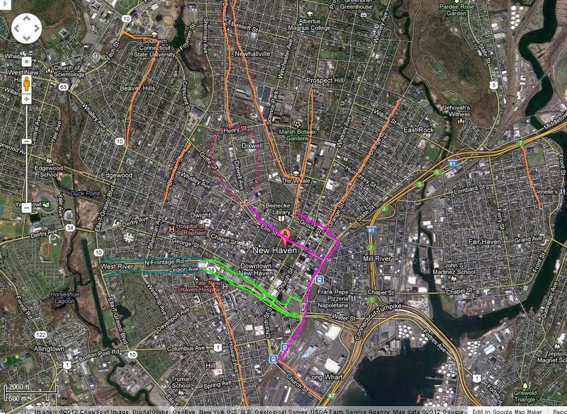
I made an aerial view to show why the two cycle tracks proposed in their 2009 survey can be so useful to the city as it continues with cycle infrastructure. Orange is existing bicycle lanes(Yes, I know Prospect doesn't extend that far, and Orange st doesn't continue between Humphrey and Grove, they're so heavily used though regardless they're basically de facto extensions of the bike lanes). Light green are raised lanes that are planned to be built as part of the Downtown Crossing project.(The darker green is where I assume they'll continue on for since it makes sense to extend it all the way to the boulevard). Purple are the proposed track.
If they build the State St cycle track, I assume they'll extend it a few hundred feet to meet the bike lanes on Howard. At that point alone you've already managed to connect a large part of downtown by cycle lanes. You'd be able to get from City point on Howard(Or Yale hospital on the other end) to East Rock, or even up into Hamden, without barely ever having to not be in a bike lane. As I said above, if the track is built on Elm, it gives them good incentive to close up the gap that would be left in Dixwell(circled) The bike lanes that will be part of Downtown Crossing on the north/south Frontage I assume will be able to directly, or come just a block away from connecting to the State St cycle track. Assuming they extend the new Frontage bike lanes all the way down to the boulevard, well, the gaps on the map fill in themselves. You extend the bike lane on the boulevard down to Frontage. You extend Sherman down to Frontage, while on the other side you build a bike lane on Goffe/Cescent, and boom, you've just connected a large part of downtown with each other solely through bike lanes. You can then continue the paths into Westville, Fair Haven and the Cove at your heart's desire.
Alas, it's all just a pipe dream for now though.
CT Livable Streets Campaign (Usuario registrado)
I like the new proposals, Brian! I think that it's critical that folks advocate for a two-way track at this location.
In terms of personal energy expenditure and exposure to elements, it's much easier for a driver to navigate their car a block or two out of the way to circle around than it is for a cyclist to have to travel out of their way. This is why many cyclists ride "the wrong direction" when one-way cycletracks are built, and why most progressive cities are favoring the two-way option.
New Haven should be following best practices, not settling for a second-best solution.
Citizen (Invitado)
Ben (Invitado)
I like this solution a lot. It would be interesting to have the engineers from Traffic and Parking join this discussion as well to see where their push back if any would be. Brian, fully agree that broad community support is most important. I think there is a way to show benefit to drivers. What does that argument look like? Less cyclists to worry about in main roadway?
Brian Tang (Usuario registrado)
I would be hesitant to make that argument. Connecticut does not have a side path law, so it would still be perfectly legal to bike with traffic, and some people might prefer to.
As for the right turns, that's a good point. I suppose the assumption with the proposal as it currently stands is that you would have to merge over to the right-hand lane, which I suppose is not ideal. Anyone know what Chicago and New York do?
I suppose it would be nice to get an update from the city. Last I heard, they had hired Milone & MacBroom to look into the possibility of a two-way cycle track on Water St, but that was over a year ago at this point.
CT Livable Streets Campaign (Usuario registrado)
Wes (Usuario registrado)
Jeffery (Invitado)
This issue is over three years old.
CT Livable Streets Campaign (Usuario registrado)
Very little has happened. The city is now talking about a striped bike lane, which is counter to the Consultant's recommendation (see OP) and is not acceptable as a way to make the street bikeable for users of all ages and abilities.
Can people call the city and ask them to do the right thing here?
BB (Usuario registrado)
zbeat (Usuario registrado)
BB (Usuario registrado)
guest (Invitado)
A simple bike lane is there now. It might make the people who already ride a bit happier, but certainly isn't the kind of change that residents overwhelmingly desire. That said it's a good sign that the city is paying attention to this issue at all.
What can we do now to make the cycle track that was recommended by the Consultant happen? The Total Cost is listed at $38,000 for a cycle track down the whole length of the street, a cost which includes bike-only traffic signals like those used for protected cycle tracks along the avenues in NYC.
Buhbye (Invitado)
adamsmith (Usuario registrado)